Project of The Developement Master Plan of Phnom Penh
Total area : 375 Km2
Inhabitants : 1.300.300
Yearly population growth: 4%
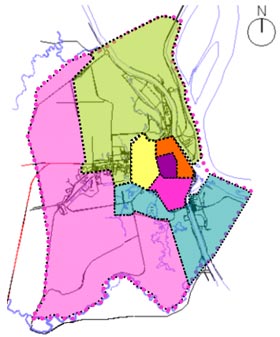
Administrative Division :
- +7 Districts
- +76 Communes
- +637 Villages
Challenges:
- Socio-Economic Development
- World Intergration and Physical Infratstruture
- Environment Preservation
- Land use Optimization and Efficiency Towards Public Servitudes
- Housing Policy and Poverty reduction
1. Socio-Economic Development
Urban Population
- One of the Capital Cities with 1.3 millions inhabitants. It is classified the 314 th city in the world.
- Population growth rate=3,2% per year about 40.000 inhab./year (NIS-1998) or about 8.000 families/year.
- GNP US$ 830 per capita , 80 times less than Thailand and Singapore.
|
Mtropole , Agglomration , Municipalit 2000 - 2020 |
|||
Source : Institut National de la Statistique ( INS ) , JICA and BAU |
|||
Population |
Municipalit source : INS |
Agglomaration Source : INS |
Mtropole |
1998 |
1039607 |
1077853 |
1333992 |
2000 |
1114479 |
1165244 |
1430066 |
2005 |
1313851 |
1403712 |
1685894 |
2010 |
1529301 |
1670230 |
1962353 |
2015 |
1753840 |
1958914 |
2250475 |
2020 |
1983104 |
2266289 |
2544659 |
2. World Intergration and Physical Infratstruture
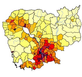
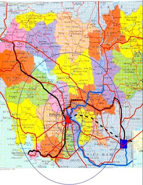
- Phnom Penh-centre of Service for 6 millions people in the range of 100Km. It is half of the whole Population of the country. (in the same range: Bangkok-9millions, Hanoi-8millions, HCM-7millions, KL-4millions, Singapore-4millions)
- By 2020 the number of that population will increase double.
Economic Intergration
Growth economic corridor :
- West-East axe
Bangkok-Phnom Penh-Hochiminh (NR1,NR2, NR5,NR6, Railways, Airway)
- North-South axe
Sihanouk Ville (Port)-Phnom Penh- Upper Mekong region (NR3, NR4, NR7, Railway, Mekong Navigation etc.)
Railway
Connections between Phnom Penh and Thailand and Sihanouk ville are in use.
Asean Railway is planned to connect Phnom Penh to the rest of the world.
We need to improved the rail and transportation condition.
Road network and Logistic Organization
- Dry port at Samrong Triangle
- Dry ports at all city gates
- Road network connects Phnom Penh to all provinces.

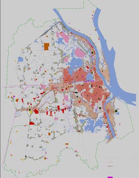
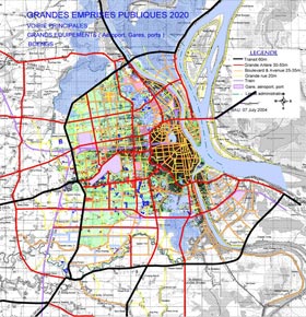
Current Land use
Total area of the capital city is about 375km3 :
- 80% natural lake and agricuture.
- 20% urban area = 6200ha
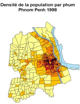
- Medium density : 130 inhab./ha (500inhab./ha in the centre and 50 inhab./in the suburb.)
Housing Policy
Following the rapid growth of about 10.000 families per year, so the city need to:
- To promote the investment on housing development esp. for the poor.
- To improve roads and other infrastructure system in the suburb area that could absorb 90% of urban growth.
- To implement the land reform and social land concession, land sharing and relocation with private partners.
- To encourage the development of dwellings for lease .
- To encourage the poor communities to rehabilitate their old settlements with the low rate loan and banking system reform.
Strategic Orientation
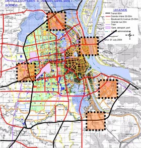
1. To define the maximum reserved area for future infrastructure system
- Future extension of airport,
- Port,
- Reserved area for ASEAN railway station at Samrong district,
- Dry ports, and
- Other reserved space for future transportation networks.
Strategic Orientation
2. To define the state land : -lakes, -canals, -rail way, -roads and -green area.
Strategic Orientation
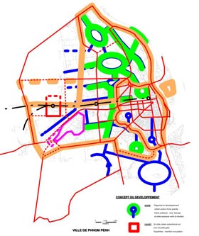
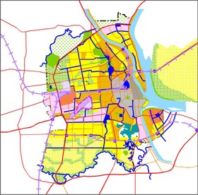
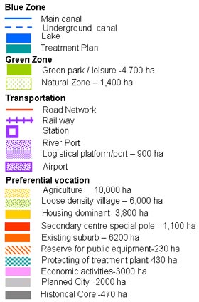
3. To create the new urban centers to prevent urban sprawl and anarchic urbanization and to promote the development in the suburban area, which are able to absorb the rapid urban growth and so that people will live next to their jobs.
 Secondary Center
Secondary Poles
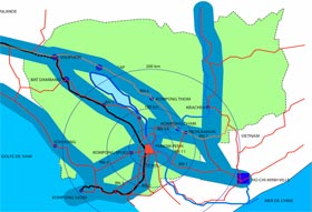
Secondary centers based On the local potentiality and future city extension :
- Chom Chao,
- Chroy Changvar,
- Chbar Ampove,
- Takmao,
- Prek Phnov
Strategic Orientation
4. To extend the city within the radius of 30km around the old centre.
5. To enhance public-private partnership to promote investment on housing development and improve land market.
Strategic Orientation

6. To enhance the identity of the city as well as the landscape (garden city) by preserving the existing traditional villages around the city, to develop and preserve the natural green system to ensure the quality of environment following the greenery master plan.
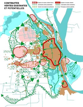
Blue belt- City Hydrological System
Strategic Orientation
Generously Supported by